Canada’s summer extreme weather refers to severe, intense meteorological events during the June-to-August period that deviate significantly from normal patterns, including heat waves, severe thunderstorms, flash floods, tornadoes, and wildfires. These events have intensified across the country in recent years, with 2026 bringing renewed urgency as communities from British Columbia to Atlantic Canada face overlapping climate threats that strain infrastructure, disrupt daily life, and challenge energy systems.
Why this matters now: the frequency and severity of these weather events continue to climb. What used to be once-in-a-century heat domes or isolated wildfire seasons now arrive with unsettling regularity. British Columbia experienced catastrophic flooding just a few years ago, while heat records have shattered in multiple provinces. This isn’t abstract future risk. Canadians are seeing the effects in evacuations, power outages, agricultural losses, and tragically, lives lost.
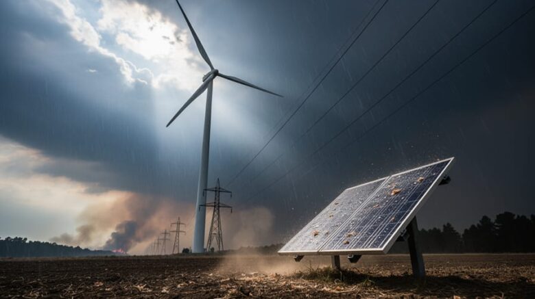
For anyone working in renewable energy or environmental fields, understanding these patterns goes beyond weather curiosity. Wind turbines must withstand stronger storm gusts. Solar infrastructure faces new hail and heat stress. Grid operators scramble to maintain power when air conditioning demand spikes during heat waves or when wildfires threaten transmission lines.
This article breaks down the types of extreme summer weather Canada faces, explains the atmospheric mechanisms driving them, and examines real-world impacts on energy infrastructure. You’ll learn how these systems develop, what makes certain regions vulnerable, and practical steps to prepare for what scientists expect will become the new baseline rather than the exception.
What Is Canada Summer Extreme Weather?
Canada summer extreme weather refers to meteorological events that exceed historical norms for the season and pose significant risks to people, property, and infrastructure. These aren’t your typical summer showers or warm spells. When Environment Canada issues warnings for conditions that threaten life and property, or when weather forces the cancellation of national celebrations like Ottawa’s Canada Day festivities, you’re dealing with extreme events.
- Extreme Weather
- Conditions that fall outside typical seasonal patterns and create dangerous situations requiring public warnings or emergency responses.
- Heat Wave
- An extended period of abnormally high temperatures, typically three or more consecutive days exceeding regional temperature thresholds, that strains power grids and threatens human health.
- Severe Thunderstorm
- A storm system producing wind gusts, large hail, or tornadoes that can damage structures and knock out power, like the Kingston tornado warning and Ottawa storms in early July 2026.
- Flash Flooding
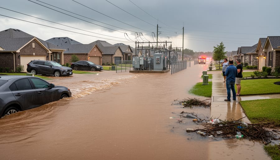
- Rapid onset flooding from intense rainfall that overwhelms drainage systems, as seen in the Manitoba storms that tore apart homes and infrastructure.
- Wildfire Conditions
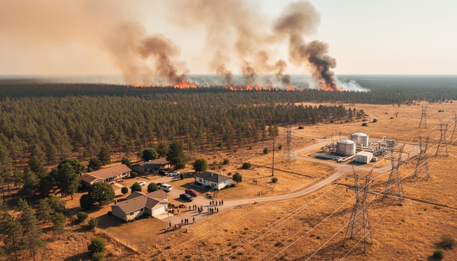
- Combination of heat, drought, and low humidity that creates high fire danger and allows wildfires to spread rapidly across forested regions.
What separates extreme from normal summer weather is intensity, duration, and impact. A typical July might bring afternoon thunderstorms and warm days. Extreme weather brings storms violent enough to issue tornado warnings, heat that forces grid operators to plead for conservation, and rainfall measured in season’s worth rather than inches.
Regional differences matter considerably. Western Canada faces flooding from intense storm systems, particularly in Manitoba where weather can demolish homes. Central regions contend with tornado threats and severe thunderstorms. Eastern provinces battle prolonged heat waves affecting Ontario, Quebec, and B.C. Northern territories struggle with wildfire conditions fueled by heat and drought. These patterns reflect Canada’s vast geography and the different air masses that collide across the country during summer months.
How Canada Summer Extreme Weather Works
The Role of Climate Change
Canada’s summer extreme weather isn’t random, it’s powered by a warming atmosphere that holds roughly 7% more moisture for every degree Celsius of temperature rise. This extra water vapour acts as fuel, intensifying storms and creating conditions where extreme weather worsening has become the new baseline. The Manitoba flooding and Ottawa storms of early July 2026 demonstrate this pattern: warmer air masses collide with greater force, dumping concentrated rainfall in short bursts rather than gentle, sustained precipitation.
Heat waves compound the problem. When temperatures climb above historical averages, as they did across Ontario, Quebec, and B.C. this summer, the atmosphere becomes more unstable. This instability feeds the severe thunderstorms that cancelled Canada Day celebrations and triggered the Kingston tornado warning. Meanwhile, prolonged heat dries out forests and grasslands, setting the stage for the wildfires now burning across Northern Canada. Each extreme reinforces the others, creating cascading risks that strain both natural ecosystems and human infrastructure, including the wind farms relied upon for clean energy generation.
Regional Weather Patterns
Canada’s geography creates distinct extreme weather zones shaped by vastly different climate drivers. The West Coast and mountain regions face intense rainfall from Pacific moisture colliding with topography, producing the flash flooding that devastated Manitoba in early July 2026. Central provinces sit in “tornado alley” where cold Arctic air meets warm Gulf systems, generating the severe thunderstorm complexes and rotation that triggered Kingston’s tornado warning. Eastern Canada experiences prolonged heat waves when high-pressure ridges stall over the region, trapping hot, humid air masses across Ontario, Quebec and B.C. for days or weeks.
Northern Canada’s extreme weather follows a different pattern. Long daylight hours and drying vegetation create ideal wildfire conditions, especially when lightning from dry thunderstorms ignites remote forests. These regional patterns aren’t random, they’re driven by Canada’s position between three major air masses (Arctic, Pacific, Continental) and the jet stream’s path, which shifts northward in summer and creates the boundaries where weather turns violent.
Types of Summer Extreme Weather Events in Canada
Severe Thunderstorms and Tornadoes
Summer thunderstorms in Canada can escalate from scattered clouds to severe systems within hours, driven by warm, humid air colliding with cooler fronts across the Great Lakes and Prairie regions. These storms pack heavy rain, lightning, hail, and occasionally spawn tornadoes when atmospheric conditions align just right. On July 2, 2026, Kingston briefly faced a tornado warning as rotating clouds threatened the area, while Ottawa cancelled Canada Day celebrations entirely when thunderstorms and flooding made outdoor gatherings unsafe. The threat these storms pose extends beyond public events, they directly impact wind energy infrastructure forcing turbines to shut down when wind speeds exceed safe operational thresholds or when lightning strikes threaten electrical systems. In southwest Winnipeg, a severe storm tore apart a house, ripped down fences, and hurled barbecues across yards, demonstrating the raw force these systems can unleash. The intensity and frequency of such events underscore why understanding storm behaviour matters for both community safety and renewable energy planning.
Heat Waves
Heat waves have emerged as one of the most persistent extreme weather threats across Ontario, Quebec, and British Columbia this summer. Unlike sudden storms, these extended periods of dangerous heat build gradually and linger for days or weeks, pushing temperatures well above seasonal norms. When the mercury stays elevated day and night without relief, human bodies can’t recover between exposure periods. Vulnerable populations, elderly residents, outdoor workers, and those without air conditioning, face serious health risks including heat exhaustion and stroke. The infrastructure toll is equally severe: power grids strain under air conditioning demand, asphalt buckles on highways, and rail lines can warp in extreme heat. For wind farms, sustained high temperatures reduce air density, which slightly decreases turbine efficiency even as cooling demand spikes electricity consumption across affected regions.
Flash Flooding
Flash flooding has emerged as one of the most destructive extreme weather events during Canada’s 2026 summer season. Unlike gradual river flooding, these events occur when intense rainfall overwhelms drainage systems within hours or even minutes. Manitoba has experienced particularly devastating impacts, where recent storms ripped apart homes in southwest Winnipeg, tearing down fences and hurling barbecues across yards. The sheer volume of water falling in short periods saturates the ground instantly, turning streets into torrents and overwhelming stormwater infrastructure designed for typical rainfall patterns. Urban areas face compounded risk because paved surfaces prevent water absorption, channeling massive volumes into concentrated flows. These flash events differ fundamentally from spring flooding, which develops gradually as snowmelt accumulates. The suddenness makes preparation difficult and evacuation challenging, particularly when storms strike with little warning. Climate scientists note that warmer air holds more moisture, meaning each storm system carries greater precipitation potential than historical averages would predict.
Wildfires
Northern Canada faces a particularly devastating dimension of summer extreme weather: wildfires that consume vast tracts of boreal forest and tundra. These fires thrive on a lethal combination of prolonged heat, minimal rainfall, and tinder-dry vegetation. Unlike sudden storm events, wildfire seasons build gradually as drought conditions accumulate, turning forests into fuel waiting for a single lightning strike or human spark. The 2026 summer has seen the North plagued by these fires, which produce massive smoke plumes that drift thousands of kilometres south, degrading air quality across the country and sometimes grounding aircraft. Firefighting efforts in remote regions prove especially challenging due to limited road access and the sheer geographic scale involved. Beyond immediate destruction, wildfires release stored carbon, alter ecosystems for decades, and threaten Indigenous communities whose traditional lands face irreversible change. The frequency and intensity of these fires have accelerated as warmer temperatures extend the fire season and dry out the landscape earlier each spring.
What Summer Storms Mean for Canada’s Wind Turbines
Turbine Protection Systems
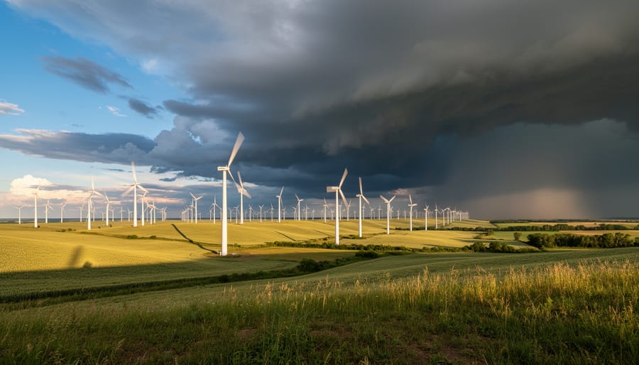
Modern wind turbines incorporate multiple layers of protection to survive Canada’s harshest summer weather. When wind speeds exceed safe operating thresholds, typically around 90 km/h for most commercial turbines, automated systems pitch the blades to a neutral position and activate braking mechanisms, bringing rotors to a controlled stop within seconds. This prevents structural damage during severe storms like those that recently hit Manitoba and Ontario.
The turbines themselves are engineered to withstand extreme conditions. Steel towers are designed with safety factors that exceed typical wind loads by 50% or more, while blade materials use reinforced composites that flex without fracturing. Lightning protection systems built into the blades and nacelle channel strikes safely to ground, essential during summer thunderstorm season when electrical activity peaks.
Advanced monitoring systems track wind speed, direction, temperature, and vibration in real-time. If sensors detect dangerous conditions, whether from approaching tornadoes or sudden microbursts, the turbine controller initiates emergency shutdown procedures automatically, no human intervention required. These protective features address many common concerns about turbine limitations during extreme weather events.
After storms pass, technicians conduct inspections before restarting operations, checking for blade damage, tower integrity, and electrical system function to ensure safe power generation resumes.

Grid Stability During Storms
When severe storms hit, wind farms face both immediate operational decisions and critical grid-support responsibilities. Most modern turbines automatically shut down when wind speeds exceed safe thresholds, typically around 90 km/h for sustained winds, to prevent mechanical damage. This protective response temporarily removes generation capacity precisely when grid demand often spikes due to air conditioning loads or emergency response needs.
However, wind farms play a vital role in power restoration after storms pass. Unlike fossil fuel plants that require lengthy restart procedures, wind turbines can resume generation within minutes once conditions stabilize. This rapid response capability proved valuable during the recent Manitoba flooding and Ontario storm events, where quick power restoration helped communities recover faster. Wind farms also provide geographic diversity that strengthens grid resilience: when storms knock out generation in one region, wind resources in unaffected areas continue supplying power.
The benefits and challenges of wind energy during extreme weather highlight an important trade-off. While individual turbines must protect themselves through shutdowns, the distributed nature of wind farms across Canada means total system failure is rare. Grid operators increasingly rely on this diversity, using weather forecasting to anticipate which wind resources will remain available during storm events and adjusting dispatch schedules accordingly. The result is a more adaptable power system that can weather disruptions better than centralized generation alone.
Uses and Applications: Learning from Extreme Weather
Canada’s string of extreme weather events this summer isn’t just causing disruption, it’s generating a massive dataset that researchers and energy planners are mining for insights. Every storm, heat wave, and flood produces real-world data about how energy infrastructure performs under stress, revealing vulnerabilities and resilience patterns that can’t be replicated in laboratory conditions.
Energy companies are using data from the Manitoba flooding and Ottawa storm systems to refine grid response protocols. When severe weather strikes, smart meters and sensor networks capture minute-by-minute information about power demand spikes, voltage fluctuations, and system failures. This information feeds directly into improved load-balancing algorithms and emergency response procedures. Some utilities now run post-storm analyses within hours, identifying weak points in distribution networks and prioritizing infrastructure upgrades based on actual failure patterns rather than theoretical models.
Climate scientists are incorporating this summer’s weather patterns into next-generation forecasting models. The combination of Northern wildfires, Central tornadoes, and Eastern heat waves provides a complete picture of how multiple extreme events interact across regions. These refined models help renewable energy developers choose turbine sites with better long-term resilience, accounting for changing wind patterns and storm intensities that older models missed.
Communities are applying lessons from recent events to emergency preparedness plans. Kingston’s tornado warning and the Manitoba home damage have prompted municipalities to map evacuation routes that account for both weather hazards and critical infrastructure locations like wind farms and substations. Some regions are now creating microgrids that can operate independently during extreme weather, using local wind generation to maintain power for emergency services when the main grid fails.
Insurance companies and infrastructure engineers are also revising their risk assessments. Each extreme weather event provides calibration data for structural stress models, helping designers build more robust turbine foundations and transmission towers that can withstand the intensifying conditions Canada now faces regularly.
Frequently Asked Questions
Canada’s extreme summer weather raises many urgent questions, especially as events like July’s Ottawa storm cancellations and Manitoba flooding become more frequent. Here are answers to what people most want to know.
What’s behind all the wild weather in Canada this summer?
A combination of climate change, shifting jet stream patterns, and natural temperature differentials are creating more intense weather systems. Warmer air holds more moisture and energy, fueling stronger storms, prolonged heat waves, and drier conditions that ignite wildfires across the North.
Is climate change making Canadian summers more dangerous?
Yes. Rising global temperatures increase the frequency and intensity of extreme events like the heat waves hitting Ontario and B.C., the severe thunderstorms that forced Kingston under tornado warning, and the wildfire conditions plaguing northern regions. The atmosphere now carries roughly 7% more moisture for every degree of warming, translating directly to heavier rainfall and worse flooding like what struck Manitoba.
How do summer storms affect renewable energy systems?
Wind turbines face both risk and opportunity during extreme weather. High winds can force automatic shutdowns to protect equipment, but storms also create peak generation periods when properly managed. Modern turbines include reinforced designs and weather-sensing systems that help them operate safely through most conditions while contributing to grid stability during and after events.
What can individuals do about extreme weather?
Stay informed through weather alerts, prepare emergency kits, and support renewable energy development to reduce future climate impacts. During active weather, follow shelter-in-place advisories like those issued during the Ottawa Canada Day storm, and avoid flood-prone areas when warnings are in effect.
These questions reflect what Canadians are searching for as summer 2026 brings one weather emergency after another. Understanding the connections between individual storms, broader climate patterns, and energy infrastructure helps communities respond effectively while planning for a more resilient future.
Types or components
Understanding the different components of Canada’s extreme summer weather system helps energy planners, infrastructure managers, and policymakers prepare for climate impacts. Each element interacts with others to create the cascading effects we’ve seen in summer 2026.
Meteorological Components include the atmospheric drivers like jet stream positioning, high-pressure domes trapping heat, and moisture-laden air masses colliding with temperature differentials. These create the underlying conditions for severe events.
Physical Infrastructure at Risk encompasses power transmission lines, wind turbines, substations, and distribution networks vulnerable to lightning strikes, flooding, and high winds. The Manitoba storms that tore apart homes also threatened electrical systems.
Human Systems involve emergency response networks, utility crews, weather forecasting services, and community preparedness programs. When Ottawa cancelled Canada Day celebrations, these systems coordinated public safety.
Data Collection Networks use weather stations, satellite monitoring, radar systems, and ground sensors to track developing conditions. This information feeds directly into operational decisions for wind farms and grid management.
Resilience Infrastructure includes the protective systems in modern turbines, backup power supplies, flood barriers, and fire suppression capabilities. These components determine how well Canada’s energy transition withstands escalating weather extremes.
Canada’s summer of 2026 has made one thing clear: extreme weather isn’t a distant threat, it’s here now, reshaping our landscapes and testing our infrastructure. From the cancelled Canada Day celebrations in Ottawa to the house-destroying Manitoba storms and Northern wildfire smoke, these events demand immediate attention and long-term solutions. The silver lining? Our renewable energy systems, particularly wind turbines, are proving resilient while offering cleaner alternatives exactly when we need them most.
You can make a difference. Support renewable energy projects in your community, whether through advocacy, investment, or simply choosing green energy options from your utility provider. Prepare your household for extreme weather by monitoring weather alerts and having emergency plans ready. Most importantly, reduce your carbon footprint through daily choices, transportation, energy use, consumption habits, because every action counts toward building a more resilient future.
The storms will keep coming, but so will innovation. Canada’s path forward lies in embracing sustainable energy solutions that can weather whatever nature throws our way while actively reducing the climate drivers making these extremes worse. We’ve got the technology and the know-how. Now we need the collective will.